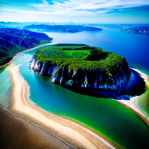
Welcome, fellow adventurers, to the captivating realm of aerial photography! Prepare to have your perspective flipped upside down, quite literally. Aerial photography, my dear readers, is the art of capturing the world from above, like a bird with a camera strapped to its feathers. It's like Google Earth on steroids, revealing hidden landscapes, secret patterns, and even the occasional nosy neighbor sunbathing in their backyard. From towering mountains to winding rivers, from bustling cities to serene countryside, aerial photography in geography grants us a bird's-eye view of our planet's breathtaking beauty. So, fasten your seatbelts, grab your cameras, and let's embark on a thrilling journey to unveil the world from above!
Aerial photography in geography is not limited to capturing images from airplanes or helicopters; it can also be done using satellites or drones. This allows for a wide range of perspectives and scales, enabling geographers to study and analyze landscapes, landforms, and human activities in a more detailed and comprehensive manner.
Ladies and gentlemen, prepare to be amazed as we delve into the fascinating evolution of aerial photography, a journey that takes us from the humble beginnings of balloons to the cutting-edge world of drones. Aerial photography in geography has come a long way, my friends. Once upon a time, intrepid photographers would ascend to the skies in hot air balloons, risking their lives for that perfect shot. But fear not, for technology has blessed us with the marvels of drones, those nimble flying machines that effortlessly capture stunning images from above. These aerial wonders have revolutionized the way we explore and understand our world, providing us with a fresh perspective on landscapes, urban sprawls, and even the intricate details of our own backyards. So, let us raise our cameras to the sky and celebrate the remarkable evolution of aerial photography!
Aerial photography in geography is not just a tool for capturing stunning images; it is a powerful instrument for conducting in-depth geographic analysis. Its applications are as diverse as the landscapes it captures. Firstly, aerial photography allows us to study land use and land cover patterns. By examining aerial images, geographers can identify different types of vegetation, urban areas, agricultural fields, and even changes in land use over time. This information is crucial for understanding the impact of human activities on the environment and planning sustainable land management strategies.
Secondly, aerial photography plays a vital role in mapping and cartography. With high-resolution aerial images, geographers can create detailed and accurate maps, capturing the intricate features of the Earth's surface. From contour lines to road networks, from rivers to buildings, aerial photography provides the necessary data for creating comprehensive and up-to-date maps that aid in navigation, urban planning, and disaster management.
Furthermore, aerial photography is an invaluable tool for studying and monitoring natural resources. By analyzing aerial images, geographers can assess the health and extent of forests, monitor changes in water bodies, and even detect geological features such as fault lines or volcanic activity. This information is crucial for managing and conserving our natural resources, as well as predicting and mitigating potential environmental hazards.
Lastly, aerial photography has found its place in archaeological research. By capturing images from above, geographers can identify and document ancient sites, uncovering hidden structures and patterns that are not visible from the ground. This aerial perspective allows archaeologists to gain a better understanding of past civilizations, their settlements, and their interactions with the surrounding landscape.
In conclusion, aerial photography in geography is not just about capturing breathtaking images; it is a versatile tool that enables geographers to analyze land use patterns, create accurate maps, monitor natural resources, and uncover hidden archaeological treasures. Its applications are vast, and its impact on geographic analysis is undeniable. So, let us continue to soar to new heights, armed with our cameras and a passion for unraveling the secrets of our world from above.
Fun fact: Aerial photography in geography is not limited to just capturing images from airplanes or helicopters. It can also be done using drones, kites, or even balloons! These unconventional methods allow for unique perspectives and angles, making aerial photography an exciting and versatile tool for studying and documenting our planet's landscapes.
As we soar higher and push the boundaries of aerial photography in geography, we must also acknowledge the challenges that lie ahead. One of the main obstacles is the cost associated with acquiring and maintaining the necessary equipment, such as high-resolution cameras and drones. Additionally, the interpretation and analysis of aerial images require specialized skills and expertise, which can be a barrier for many researchers and geographers. Furthermore, the ethical considerations surrounding privacy and data protection in aerial photography must be carefully addressed to ensure responsible and respectful use of this technology. However, despite these challenges, the future prospects for advancing aerial photography in geography are promising. With ongoing advancements in technology, such as improved sensors and image processing techniques, we can expect even higher resolution and more detailed aerial images. Moreover, the integration of aerial photography with other geospatial technologies, such as remote sensing and geographic information systems (GIS), will further enhance our ability to analyze and understand the complex dynamics of our planet. So, let us embrace these challenges and seize the opportunities that lie ahead, as we continue to unlock the full potential of aerial photography in geography.
